RESULTS ON A MAP
(read WARNING below)
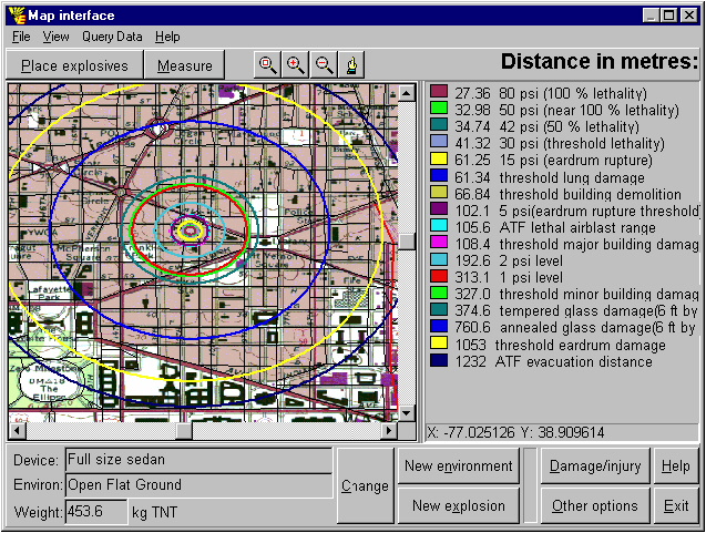
Example: Damage and injury distances are overlaid as circles on a map of Washington DC. The circles appear as ellipses because the longitude and latitude are plotted, rather than 'projected' map coordinates, in the trial version. Licenced versions of EBlast will be interfaced to the user's existing GIS.
|
WARNING: The results shown above are made deliberately INCORRECT to prevent their inappropriate use. Only licensed EBlast users will be provided with accurate results. |
In addition to damage and injury circles, a legend is displayed and radius values listed. The GIS coordinates of the explosion centre are displayed (X=longitude and Y=latitude) . The menu bar and buttons at the top of the screen are used for manipulating the GIS display: moving the explosive, changing maps, measuring distances between points, zooming, centering, querying associated databases, etc. Such operations will already be familiar to the user of the GIS system being interfaced by
EBlast.
To return to the bar chart display, we would click 'Damage/injury' above. Clicking 'Map interface' on the other screen would bring us back to the screen above (without the map list shown previously). The other buttons shown above at the bottom are the same on each display screen. On either screen, for example, to change the the environment, we could click the 'New environment' button.
Let's do just that, select 'New environment' and after that, 'Between or near buildings'.
Next | Back | Quit